ANalysis
Linking Housing Opportunity TO School Opportunity
In October 2024, HousingForward Virginia released the third installment of the Virginia Zoning Atlas covering the nine localities in the Greater Richmond area. In a first-of-its-kind analysis, the team combined their regional Atlas data with an existing dataset tracking diverse & white-majority schools. In the City of Richmond, they found that areas within one mile of whiter schools have less opportunities for developing multifamily housing than areas with more diverse schools. Overall, they found that "the ability to build affordable housing near high opportunity schools can be stifled by zoning."
Chart depicting percent of land that allows multifamily housing within one mile of diverse and white-majority schools, courtesy of HousingForward Virginia.
Minimum Lot Sizes, Big Consequences
As New England states make sense of the land use policies that have caused a decades-long strain on their housing supply, journalists are ringing the alarm about a key regulatory culprit: minimum lot sizes. When required lot sizes trend larger, opportunities to build dense, affordable housing disappear. Even in densely forested New England landscapes where lot requirements may fairly respond to environmental considerations, stakeholders are calling to re-examine these rules in the places most appropriate for redevelopment.
The Public’s Radio spoke with the NZA and our partners at HousingWorks RI, the team behind the Rhode Island Zoning Atlas, to develop findings around how much land is tied up in large lots for single family zoning. In Rhode Island, zoning atlas data reveals a staggering 43% of developable land requires at least two acres of land for a single family home.
Chart comparing minimum lot sizes (measured as a percentage of zoned land) in Rhode Island, Connecticut, and New Hampshire, courtesy of The Public’s Radio.
Enhancing an Annual Publication
The Rhode Island Zoning Atlas is already playing a role in discussions about housing affordability across the state—in Kent County and beyond. Its insights played a crucial role in the “Fact Book” published annually by HousingWorks RI at Roger Williams University, a key National Zoning Atlas partner.
HousingWorks RI said that its “important work” with the National Zoning Atlas combined with its other modes of analysis to offer a “holistic view of housing as an indicator of both individual well-being and emergent community challenges.”
A page out of HousingWorks RI’s 2023 “Housing Fact Book” featuring statistics informing the community’s housing stock and zoning compliance.
A Deeper Regional UNderstanding
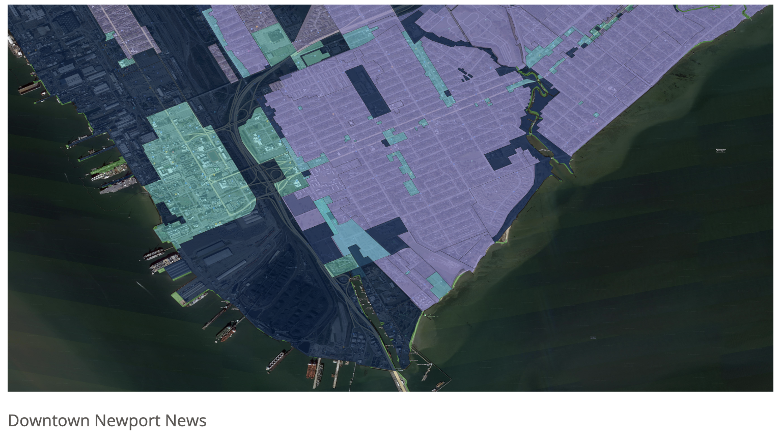
The Virginia Zoning Atlas, lead by a team of policy experts at HousingForward Virginia, debuted the first leg of their atlas alongside a comprehensive analysis of zoning’s impact in the Hampton Roads coastal region.
The team compiled a repository of tables, maps, graphs, photographs and textual descriptions that reveal majority of the region’s developable land is dedicated to single-family, detached homes in residential-only districts — even in non-rural, downtown settings. Additional analysis addressed the zoning’s relationship to transit access and need for affordable housing.
Zoning district types hyper-imposed over satellite imagery encouraging the use of mixed-use zoning (in light blue) in downtowns, courtesy of HousingForward Virginia.
story map Spotlights ZoninG’s regional and Statewide Trends
To accompany the release of the New Hampshire Zoning Atlas, the team created an interactive story map comprising statewide and regional analyses of key zoning regulations. The scrollable tool displays side-by-side visual representations of zoning variables by county, like land dedicated to single and multi-family housing treatments, ADUs, and manufactured housing, alongside additional maps indicating where the zoning may mislead or is mismatched with actual building potential when taking into account restrictions like large lot size.
Maps from the NH Zoning Atlas story map displaying a mismatch between land permitting small lot single-family homes and actual small lot single-family new building potential in the Manchester metropolitan area.
Apples-To-Apples Comparisons In Northern Virginia
A key partner of the Virginia Zoning Atlas, Mercatus Center at George Mason University compiled a zoning atlas for Northern Virginia, released in May 2024. The team used the atlas to conduct a thorough analysis looking at which zoning levers may restrict or welcome new and/or diverse types of housing construction in the region, such as allowances for “light density” and ADUs. The NZA's bespoke data collection methodology enabled the team to make apples-to-apples comparisons of jurisdictions in the focus area, honing in on potential policy improvements that span the local to regional scale.
Graph comparing land allotted to single-family zoning by jurisdictions in the included in the Northern Virginia Zoning Atlas, courtesy of Mercatus Center.


